Search Earthquake Catalog
online search by time window, area, magnitude, and more
online search by time window, area, magnitude, and more
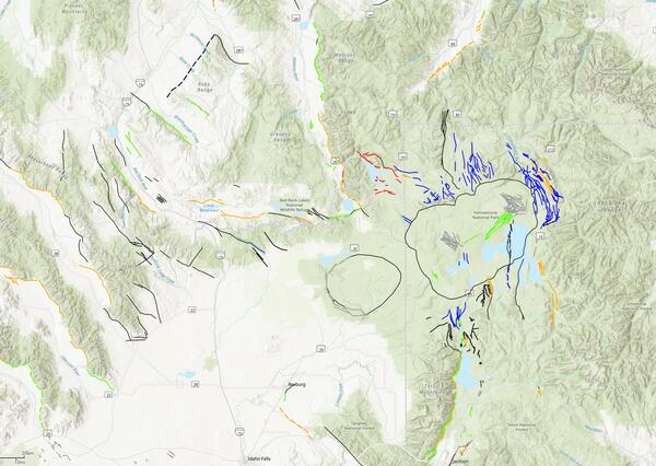
Machine Learning Mapping in the Sierra Nevada Mountains
A new study mapping the bedrock outcrops in California
A new study mapping the bedrock outcrops in California
Significant Earthquakes, Past 30 days
Significant Earthquakes, Past 30 days
6.3
131 km SE of Vilyuchinsk, Russia
2025-07-30 00:16:03 (UTC)
Pager Alert Level: Green
MMI: IV (Light Shaking)
10.0 km
6.9
147 km SE of Petropavlovsk-Kamchatsky, Russia
2025-07-30 00:09:54 (UTC)
Pager Alert Level: Green
MMI: V (Moderate Shaking)
10.0 km
8.8
2025 Kamchatka Peninsula, Russia Earthquake
2025-07-29 23:24:51 (UTC)
Pager Alert Level: Red
MMI: VIII (Severe Shaking)
20.7 km
6.6
553.0 km
6.9
31.0 km
6.5
258 km WNW of Sabang, Indonesia
2025-07-28 18:41:49 (UTC)
Pager Alert Level: Green
MMI: V (Moderate Shaking)
10.0 km
6.6
176 km SSE of Mata-Utu, Wallis and Futuna
2025-07-24 23:37:57 (UTC)
Pager Alert Level: Green
MMI: IV (Light Shaking)
314.2 km
6.3
109 km W of Gorontalo, Indonesia
2025-07-23 20:50:44 (UTC)
Pager Alert Level: Green
MMI: V (Moderate Shaking)
144.6 km
6.2
92 km SSE of Sand Point, Alaska
2025-07-20 22:28:00 (UTC)
Pager Alert Level: Green
MMI: V (Moderate Shaking)
40.0 km
6.6
147 km E of Petropavlovsk-Kamchatsky, Russia
2025-07-20 07:22:59 (UTC)
Pager Alert Level: Green
MMI: V (Moderate Shaking)
9.4 km
6.6
151 km E of Petropavlovsk-Kamchatsky, Russia
2025-07-20 07:07:43 (UTC)
Pager Alert Level: Green
MMI: V (Moderate Shaking)
10.0 km
7.4
2025 Eastern Kamchatka, Russia Earthquake
2025-07-20 06:49:01 (UTC)
Pager Alert Level: Yellow
MMI: VII (Very Strong Shaking)
10.0 km
6.6
142 km E of Petropavlovsk-Kamchatsky, Russia
2025-07-20 06:28:18 (UTC)
Pager Alert Level: Green
MMI: V (Moderate Shaking)
23.0 km
5.4
35 km ENE of Shwebo, Burma (Myanmar)
2025-07-18 09:30:04 (UTC)
Pager Alert Level: Yellow
MMI: VII (Very Strong Shaking)
10.0 km
6.3
131 km SE of Vilyuchinsk, Russia
2025-07-30 00:16:03 (UTC)
Pager Alert Level: Green
MMI: IV (Light Shaking)
10.0 km
6.9
147 km SE of Petropavlovsk-Kamchatsky, Russia
2025-07-30 00:09:54 (UTC)
Pager Alert Level: Green
MMI: V (Moderate Shaking)
10.0 km
8.8
2025 Kamchatka Peninsula, Russia Earthquake
2025-07-29 23:24:51 (UTC)
Pager Alert Level: Red
MMI: VIII (Severe Shaking)
20.7 km
6.6
553.0 km
6.9
31.0 km
6.5
258 km WNW of Sabang, Indonesia
2025-07-28 18:41:49 (UTC)
Pager Alert Level: Green
MMI: V (Moderate Shaking)
10.0 km
6.6
176 km SSE of Mata-Utu, Wallis and Futuna
2025-07-24 23:37:57 (UTC)
Pager Alert Level: Green
MMI: IV (Light Shaking)
314.2 km
6.3
109 km W of Gorontalo, Indonesia
2025-07-23 20:50:44 (UTC)
Pager Alert Level: Green
MMI: V (Moderate Shaking)
144.6 km
6.2
92 km SSE of Sand Point, Alaska
2025-07-20 22:28:00 (UTC)
Pager Alert Level: Green
MMI: V (Moderate Shaking)
40.0 km
6.6
147 km E of Petropavlovsk-Kamchatsky, Russia
2025-07-20 07:22:59 (UTC)
Pager Alert Level: Green
MMI: V (Moderate Shaking)
9.4 km
6.6
151 km E of Petropavlovsk-Kamchatsky, Russia
2025-07-20 07:07:43 (UTC)
Pager Alert Level: Green
MMI: V (Moderate Shaking)
10.0 km
7.4
2025 Eastern Kamchatka, Russia Earthquake
2025-07-20 06:49:01 (UTC)
Pager Alert Level: Yellow
MMI: VII (Very Strong Shaking)
10.0 km
6.6
142 km E of Petropavlovsk-Kamchatsky, Russia
2025-07-20 06:28:18 (UTC)
Pager Alert Level: Green
MMI: V (Moderate Shaking)
23.0 km
5.4
35 km ENE of Shwebo, Burma (Myanmar)
2025-07-18 09:30:04 (UTC)
Pager Alert Level: Yellow
MMI: VII (Very Strong Shaking)
10.0 km
Earthquake Hazards Program
The USGS monitors and reports on earthquakes, assesses earthquake impacts and hazards, and conducts targeted research on the causes and effects of earthquakes. We undertake these activities as part of the larger National Earthquake Hazards Reduction Program (NEHRP), a four-agency partnership established by Congress.
Latest Earthquakes
Latest Earthquakes

Latest earthquakes map and list (past 24 hours, M2.5+) from the ANSS (Advanced National Seismic System).
Search Earthquake Catalog
Search Earthquake Catalog

Find an earthquake or a list of earthquakes by time window, magnitude, area, and more, and choose the output format - map and list, CVS, and others.
News
USGS Geologic Mapping Project Supports Critical Mineral Exploration, Enhances Public Safety in the Southeast
USGS Geologic Mapping Project Supports Critical Mineral Exploration, Enhances Public Safety in the Southeast
USGS Announces Recipients of Recent Earthquake Research Grants and Cooperative Agreements
USGS Announces Recipients of Recent Earthquake Research Grants and Cooperative Agreements
M7.7 Mandalay, Burma (Myanmar) Earthquake
M7.7 Mandalay, Burma (Myanmar) Earthquake
Publications
Reflections on a trio of North American earthquakes in 1925 Reflections on a trio of North American earthquakes in 1925
In 1925, three moderately large damaging earthquakes occurred in North America over four months: the 28 February (local time; LT) M 6.2 Charlevoix, 27 June (LT) M 6.6 Montana, and 29 June M 6.5 Santa Barbara earthquakes. The centennial anniversaries of these events motivated this retrospective consideration focused on the ground motions generated by the three events, including a...
Rupture process of the Mw7.0 December 5, 2024 Offshore Cape Mendocino earthquake Rupture process of the Mw7.0 December 5, 2024 Offshore Cape Mendocino earthquake
The Mw7.0 December 5, 2024 Offshore Cape Mendocino earthquake ruptured a km long portion of the east-west trending Mendocino fault zone (MFZ). In order to clarify the rupture process, we assemble three-component seismograms from regional seismic stations, horizontal coseismic displacement vectors derived from Global Navigation Satellite System (GNSS) time series, and a Sentinel-1...
Evidence for fluid pressurization of fault zones and persistent sensitivity to injection rate beneath the Raton Basin Evidence for fluid pressurization of fault zones and persistent sensitivity to injection rate beneath the Raton Basin
Subsurface wastewater injection has increased the seismicity rate within the Raton Basin over more than two decades, with the basin-wide injection rate peaked between 2009-2015. To understand the evolution of injection-induced earthquakes, we systematically analyzed 2016-2024 broadband recordings with a machine-learning-based phase picker and constructed a catalog with 95,993 earthquakes...
Science

Engineering and Risk
The well-known statement "Earthquakes don't kill people, buildings do" highlights the need to make our communities more earthquake resilient. The impact of earthquakes on public safety and the national economy can be reduced through improvement of the built environment to resist earthquake effects such as ground shaking. Extending natural hazards science to risk involves (1) conducting research to...

2025 Puerto Rico and U.S. Virgin Islands Long-term National Seismic Hazard Model
We anticipate the final 2025 PRVI NSHM to be available by December 21st 2025.
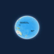
Public kickoff webinar: 2026 National Seismic Hazard Models for Guam & Northern Mariana Islands and American Samoa
Monday, February 24, 2025 2:00-4:00 pm MST A Virtual Meeting


 Earthquake")